- Community Spotlight, Success Stories
- Environmental Resource Assessment & Management
Expanding a Popular Flood Exposure Tool
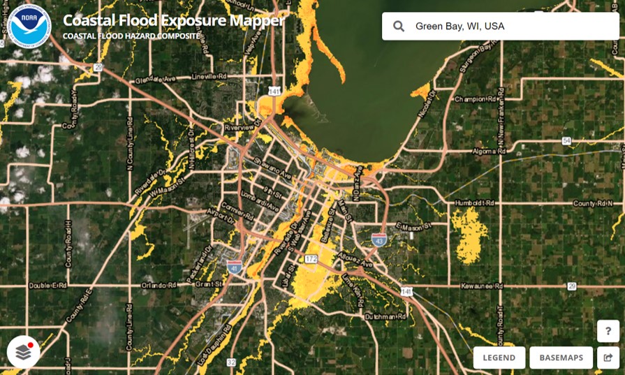
We recently assisted our client, the National Oceanic and Atmospheric Administration’s (NOAA) Office for Coastal Management, with updating one of their most popular tools, the Coastal Flood Exposure Mapper. Our staff provided data management, content development, and outreach support to expand the coverage to the U.S. Great Lakes for some of the flood layers, as well as to include tsunami zones for the East Coast. With this update, users can now view people, places, and natural resources exposed to new flood risks in areas previously not available.
In addition, our communication specialist recommended a higher level of outreach efforts for this expansion to more broadly advertise the implications for the Great Lakes region. This led to engaged interest from NOAA, congressional notifications, a press release, and social media rollouts.
Visit NOAA’s Digital Coast to explore this tool.
See More Success CSS Stories
Advancing Severe Weather Predictions with Artificial Intelligence
As artificial intelligence (AI) and machine learning (ML) technologies evolve in Earth sciences, CSS employee owners (formerly Riverside staff) are growing our expertise in this field. CSS employee owners are advancing technologies for our client, NOAA’s Center for Satellite Applications and Research (STAR). Our staff have developed a framework, exploiting modern AI/ML techniques, to rapidly…

Training Marine Mammal Programs to Use Drones to Collect Dolphin and Whale Respiratory Health Data
CSS employee owner and Marine Mammal Drone Specialist supports NOAA’s National Centers for Coastal Ocean Science (NCCOS) Marine Mammal Health Assessment team with collecting respiratory health data from marine mammals in local waterways. Using specialized drones equipped with petri dishes provides a non-invasive method to collect exhaled breath (i.e. blow) samples from dolphins and whales.…
Evaluating the Use of Earth Observations Digital Twin Technologies
Earth Observations Digital Twin technologies are data analytics, artificial intelligence, and advanced modeling technologies that provide an estimate of the true state of the Earth. An Earth Systems Digital Twin is observations-based and grid-flexible with multiple components and high-resolution data over space and time to capture all available observations and feed a variety of direct…